Posted in Fun

Easin’ Along – Discovered Solomon’s Island, MD

Causeway to Solomon's Island
Causeway to Solomon’s Island, MD

We had a delightful time on our visit to Norfolk Naval Base, our tour of the nuclear submarine, USS Boise, and our climb up the Cape Henry Lighthouse. We hope our readers enjoyed the visit as well. Now, we have the opportunity to tell you about the next new place we discovered and have been exploring for the last two days. It truly has been love at first sight.

We are staying at the Patuxent River Naval Air Station or “Pax River” as Navy personnel refer to it. It is located on the Patuxent River which is the longest river in the State of Maryland and feeds into the Chesapeake Bay. We arrived on Saturday (8/22), and checked into a lovely room in the Navy Lodge.  We’ve been on the road for six days now, so the task of sorting out what is needed, and which bags to lug in, is becoming less arduous than when we started. We settled in quickly.  Once we had everything place, we asked Desirae, our very friendly Lodge host, about her recommendations for dinner. Without hesitation, she said we needed to take the ten minute drive to Solomon’s Island…we’ll never repay the favor.

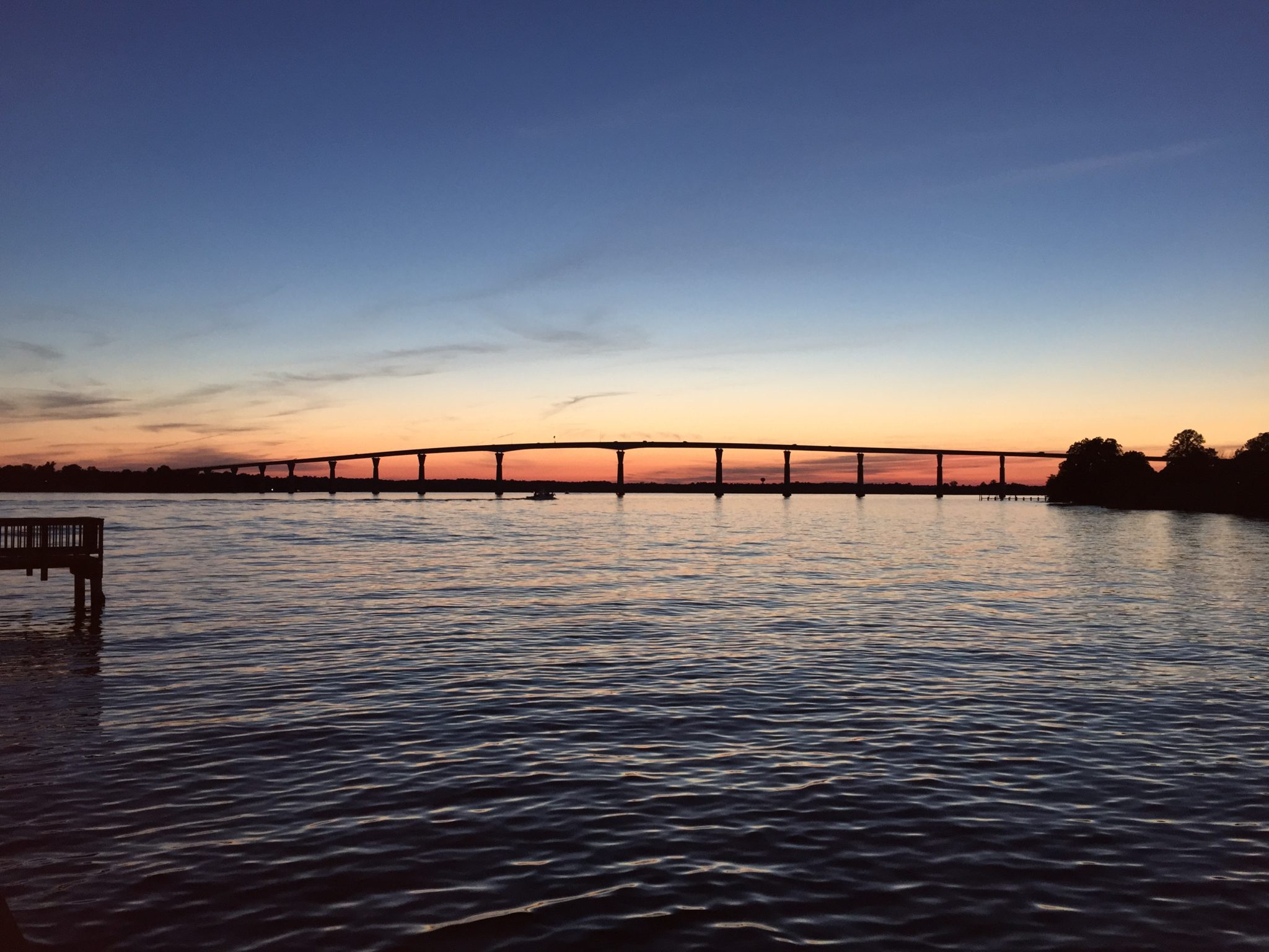
The drive itself is simply spectacular.  After leaving the highway adjacent to the base and following the signs leading to Solomon’s Island you soon come to a bridge that rises steeply and crosses the Patuxent River. Below the bridge you could see several marinas filled with sailboats and some beautiful waterfront homes scattered about.  We were traveling with the setting sun behind us and the view of the waterfront and the sailboats in our foreground is one we’ll not soon forget. Solomon’s Island was once a real island, but, at some point in the past, the northern end of the island was filled in with dredged material and the island became part of the peninsula. Also, once the causeway bridge was built, Solomon’s became connected to the mainland and saved its visitors a twenty five mile drive to a bridge to the north that would eventually allow one to reach the town.

On this Saturday evening the activity level was brisk as there were many families on the short boardwalk and fishing pier which runs along the Patuxent River. There are several public parking lots beside the boardwalk but I had to search hard to find a spot for us. As luck would have it, a van pulled out of a spot in front of me just as I was about to give up.

Solomon’s Island is both quaint and small so the restaurant choices are somewhat limited.  Helen had done her thing and decided that we would give Stoney’s Seafood restaurant a try based on the reviews in Trip Advisor. We wanted Maryland crab cakes, and all reviews led to Stoney’s.

We were seated outside on the deck over the water and things couldn’t have been more perfect. The weather was as good as you could want. Temperature in the low 70’s, no wind, setting sun. There were ducks floating around the deck and we spotted an occasional jellyfish checking us out during our dinner. We were greeted by our waiter, Joey, and ordered a craft beer that was brewed locally.  I’ve posted a link to Stoney’s here, so please check them out. Our meal was awesome!

View from Stoney's deck
View from Stoney’s deck

After dinner, we took a stroll along the boardwalk to walk off our meal and found that experience equally delightful.  Lots of children were lined up at the soft serve ice cream stand and playing on the playground nearby.  We were taking pictures of the sky as the sun had dipped below the horizon, when a young man walked up and offered to take our picture.  We relented. We soon set out for our temporary home at the Navy Lodge, but resolved to return the next day.

Boardwalk after dinner

The next morning, Sunday, we rose early and helped ourselves to the breakfast served at the lodge. We next did some exploring around this huge base which fronts the Chesapeake Bay. Pax River Naval Base was created in 1943 to test aircraft and aircraft parts for use in World War II. It still does some of that, but it also hosts a school for Navy test pilots.  We learned that the runway here is two and a half miles long and is the longest runway on the East Coast. We drove around it on this excursion then set out for the return trip to Solomon’s.

By now it was near lunchtime so we decided to go somewhat big for lunch and somewhat light for dinner.  Tough choices, but we do know how to rough it!

Again, based on Trip Advisor, we ventured to the Dry Dock Restaurant at a marina on Solomon’s Island. Our waiter was a nice young man who gave us his name, but I didn’t quite catch it.  I think it was Adolfo, but if I’m wrong, I hope he’ll forgive me because the service was super.  Helen (adorable wife) ordered grilled scallops served on quinoa, and I asked for fried oysters eggs benedict.  We summarized the details of our lunch in a separate post in the food segment of Easin’ Along.  Here is a link to that post. Trust me, we ate well.

After lunch Helen wanted to take a boat ride to tour this lovely area by water.  The hostess at the Dry Dock told us that the Calvert Marine Museum just up the street had just what we wanted.

We made it to the Museum with just nine minutes to spare before the next cruise. We paid our seven dollars each (senior discount rate once again), and hopped on the William B. Tennison for a one hour cruise of the Patuxent River and the Chesapeake Bay around the southeastern point of Solomon’s Island. We joined maybe twenty other passengers for a splendid afternoon on the water.

Wm. B. Tennison cruise vessel

The ship captain narrated the cruise and did an excellent job giving us the history of the island and directing us to the many points of interest both on shore and off. One of the most interesting things he shared with us related to the boat we were on.  The William B. Tennison was built in 1899 in Baltimore as a two mast sailing vessel and used for dredging for oysters.  It was constructed from nine hollowed logs in the construction method prevalent in the the time it was built. Later, it was converted to a motorized vessel and moved to this area where it was purchased by the museum for tourism.

As we came back in to port we were greeted by a group of senior citizens who had gathered to pilot their remote controlled sailboats from the dock behind the museum. The small sailboats were impressive and you could tell that these fellows were having a grand afternoon.

Remote control boat
Remote control sailboat
Remote control sailboat "Navy"
Remote control sailboat “Navy”


A small piece of us now resides at Solomon’s Island.  Glad you could be there to share it with us. We’ll be Easin’ Along back to the Navy Lodge.Print

Posted in Fun

Easin’ Along from Nag’s Head to Kitty Hawk, NC


Nag’s Head, NC

Nags Head

Helen (adorable wife) and I have never been to the Outer Banks and knew this was the opportunity to change that.  So, after a quick run thru the Marine Base at Cherry Point, NC for ice, essentials, and McDonald’s for breakfast, we set out for Nag’s Head on a beautiful day and a lovely three hour plus drive along the North Carolina coast.

Our first stop in Nag’s Head was at Jeannette’s Pier to stretch our legs and get our bearings.  Jeannette’s Pier is sort of the focal point of the town and is a large pier with numerous displays in the Visitor Center relating to the environment and aquatic life.  On this day the Visitor Center was BUSY.  There are several fee based activities available on the pier including fishing for one day (or more), fishing equipment rental (one day or more also), annual passes, or a simple walk on the pier.  We decided that the two dollar pass to walk was what we needed, but the line to pay was slow as it seemed every group in line wanted a different option and the two cashiers were having a time of it keeping up with who wanted what. They seemed relieved that we only wanted to walk!

Poster on Jeannette's Pier
Poster on Jeannette’s Pier

The wait was worth it…Even though Nag’s Head was more built up than we expected, the view of the shoreline from the pier is still a sight worth seeing especially on a day like this one. There were a lot of people fishing – some serious, but lots of rookies – and we saw fish being caught.  One gentleman hooked a large Skate (Sting Ray) and was having great difficulty getting it under control.  He attracted a sizable crowd of onlookers. We Eased Along slowly to the end and back and chatted with a few anglers along the way.

We returned to the Visitor Center and spent a little time at the aquatic tanks holding a  variety of live fish found in the area…very well done.

As we left the Visitor Center our attention was drawn to the several windmills posted along the pier which were in full motion, and were reminded of the reason that Aviation was born here. The wind…

Kill Devil’s Hill – Kitty Hawk, NC

Wright Bros Monument
Wright Brothers Monument on Kill Devil Hill

On a cold, blustery day in December, 1903, Wilbur and Orville Wright, two bicycle mechanics from Ohio, successfully completed an “experiment” and fulfilled a lifelong dream of sending man into the air to join the birds. In doing so, they changed forever the world in which we live.

As a tribute to those to men and their unconquerable determination and faith, the Wright Brothers Memorial was established at the site of that first flight in Kitty Hawk, NC.  We had to see it.

The Wright Brothers Memorial is a National Park just a few miles north of Nag’s Head, NC.  When arrived the Park Ranger took one look at us and, to our utter amazement, guessed that we were over 62 years old. He then asked if we had a National Park Senior Pass to which we replied that we did not.  He explained that for ten dollars and an ID he would issue us a lifetime pass to any National Park and we also would qualify us for other discounts as available.  Here is a link to a post on the Senior Pass, and the Passport book…it’s a great deal.

The Visitor Center was buzzing with activity on this hot, humid, but otherwise glorious day.  Once inside we viewed the many photographs and other displays that chronicled the incredible journey of these two men that led to this awesome achievement. We were led to a rather large auditorium with three or four rows of chairs on two sides of a full size replica of the airplane that made that first flight. The chairs were filling up fast for one of the afternoon presentations so we grabbed two in the middle of the front row. The presentation was due to start in about ten minutes so we took advantage to the time to scroll through our phones to catch up on email, Facebook posts, etc. Technology…thank goodness the Wright Brothers didn’t have these distractions!

Wright Bros replica
Replica of original airplane

Soon, a young Park Ranger wearing the name tag of Hillary Fine walked up beside the replica beaming with a huge smile and gave out a very energetic “Hellooo everyone”. She had us from that “hello”. For the next thirty minutes or so, Ranger Fine, without notes or an occasional moment to gather her thoughts, verbally drew a picture for us of the effort these men gave in order to send man into the sky. The story is an overwhelming one, and you could have heard a pin drop in that auditorium.

When the story was completed we were directed to the original airfield behind the Visitor Center to observe the granite markers marking the lift-off point and the finishing points for each of the four flights made on that December day. I’m sure that I didn’t know how short the first flight actually was, but I was dumbfounded when I learned that it only went 120 feet and lasted a total of twelve seconds! We walked to the marker at the end of that first flight about the time a jet flew over and realized how far we’ve come. The last marker, representing the fourth and final flight was 852 feet away, and that flight took a whopping 59 seconds. By then, the brothers were apparently feeling pretty confident and planned to fly to a point four miles away, but we were told that a gust of wind came up, caught their plane at rest, and damaged it beyond repair. The Wright Brothers returned home in time for Christmas.

We left the airfield to go to the monument on Kill Devil’s Hill, a minute’s drive away. To reach the monument, we had to walk up the hill, and even though it was pretty hot and steamy, we decided we had to go for it.  After all, if the Wright Brothers and a few assistants could carry a glider up the hill for over one thousand experimental flights, we surely could get up there with an IPhone!

Original airfield (now grass covered)

The Memorial was impressive, and the view of the airfield and surrounding coastline was stunning on this beautiful day.  The wind never subsided…

We left the Memorial, but the impressive achievement that took place here will stay with us forever.  I’ll never board a plane again without thinking that the trip I’m about to take began with a twelve second flight.

We left having been both amazed and inspired.  Time to be Easin’ Alonglogo-square


Posted in Fun

Easing Along from Kure Beach to Beaufort, NC


Coquina Outcrop 1
Coquina Outcrop – Kure Beach, NC


Editor’s note: This article was first posted on 8/15/2015 and shortly after I retired. It is one of the first posts on Easin’ Along. We’re going to visit Kure Beach again in the next few weeks so I featured it on our homepage. I love the picture above and remember taking it shortly after sunrise…so tranquil.

I needed to decompress after retiring so what better place to do that than at the seashore?

We also wanted to visit some places that we had never ventured to before so we planned a route that would let us do that as much as possible and, looking at a map, we spotted the name Kure Beach, NC–never heard of it. We were aided in our search by the Temporary Military Lodging guidebook published by Military Living Publications. We found the phone number for Fort Fisher Air Force recreation area and gave them a call.  As a retired officer in the Army Reserve, I am able to use that privilege on a space available basis.  Luck was with us and we were able to book a room for two nights.

What a treat! Kure Beach is about 20 miles south of Wilmington, NC and sits alongside of the Cape Fear River.  The town itself is almost an extension of Wilmington with Carolina Beach in between the two.  There are shops and restaurants much like a typical beach town and rows of beach houses and inns scattered along both sides of the highway running through the town.

Kure Beach Pier
Kure Beach Pier

The focal point of Kure Beach is a large pier that functions as an activity center and gathering place for both tourists and residents alike. We strolled along the pier on both nights we were there and loved seeing the families, fishermen, and old folks (like us) gathered to visit and watch the waves roll in.  We were there to walk off our meals (more later).

The true gem of Kure Beach (pronounced curry) is the beach itself.  No large crowd to fight with, we were able to pick our spot and enjoy the waves while sitting in our chairs and letting the weariness from hours of driving go by.  At the Southern end of the beach is a large outcropping of rocks known as the Coquina Outcrop.  At first glance, it looks like a large rock covered in algae when, in fact, it is actually an ecosystem of aquatic life of all varieties.  Birds like Sanderlings and Gulls were scattering about to see what they could find for breakfast amongst the crevices in and around the rocks and it was fun to see the small sea creatures dive and resurface as the waves rolled in and out. The picture at the top of this post is the Outcrop at low tide.

Fort Fisher – Site of original wall

On our second day we took a twenty minute ferry ride across the Cape Fear river to the town of Southport, a charming old city that had an abundance of small shops for browsing. We enjoyed it very much, but the weather was a bit iffy and we wanted to get our car back across the river in time to see Fort Fisher before dark and before the ferry filled up. We had really planned to take a second ferry to Bald Head Island and do some exploring there, but we’ll have to save that for another day.

Fort Fisher is located on a State Historical area and is the site of the largest Naval Bombardment of the Civil War.  The Visitor Center had a large display of photographs and relics of the period as well as a theater where a moderator explained the details of the two bombardments that took place there in December,1864 and January of 1865.  Here is a link to this historical center’s website.

On day three of this journey we packed up and headed north.  We wanted to do some sightseeing around the Outer Banks so we booked a room at Cherry Point Marine Aviation Station for one night, again thanks to Military Living’s publication. After checking in to an exceptional room at the Devil Dog Inn on post, we lit out for the town of Beaufort, NC which is about twenty miles away.  By the way, this Beaufort is pronounced “Bo-furt”. Like Southport, Beaufort is small and quaint with a nice Boardwalk along the riverfront.  We ate dinner at the Front Street Grill and watched many sailboats come into the Marina from our table on the deck.  Delightful! Please go to the Picture Gallery for more. 

Helen at dinner in Beaufort

From Cherry Point we packed up and headed to the Outer Banks to visit Nag’s Head and Kitty Hawk and the Wright Brothers Memorial–the highlight of the trip so far! (click here)  I’m running out of time for this post, so come back and I’ll tell you all about this inspiring experience.  For now, we’ll be Easin’ Along.Logo square