Posted in Fun

Moab Part Two – Arches National Park

Pine Tree Arch – Arches National Park, Moab, Utah

Beautiful yet fascinating is the way I would describe Arches National Park. I’ll let the pictures attempt to portray some of the beauty in this gem of a National Park located just a few miles from downtown Moab, Utah. It is the 2,000 arches and the incredible forces that created them make the rest of this story so fascinating.

Balanced rock

As we told readers last week, we were advised to visit Arches National Park early in the day because the park is very popular and long lines of cars can form at the entrance later in the day. An early departure caused us to forgo our usual morning routine of lingering long over coffee and breakfast and drive Butch (truck) five miles to the entrance shortly after the gates opened. The lines had already formed but they were relatively short.

Arches National Park – Moab, Utah

We waved our National Park Senior Pass at the Park Ranger and received a welcoming smile in return along with maps of the Park and the hiking trails. The Visitor Center was the first stop.  After a short wait, the doors to the theater opened and we watched a very informative documentary on the creation of the rock formations and the history of Arches National Park.

After viewing the film, Helen read through the trail maps and peppered the Rangers inside the Visitor Center with questions about what to see and where to hike. The day was cloudy and very light rain fell around us which factored into our agenda.  We decided to begin our hike at the Devil’s Garden Trailhead and hike to Landscape Arch, stopping to visit two other arches along the trail.

Devil’s Garden Trail – Arches National Park

Despite the early start, visitors filled the trail. Approximately one-third of the way to Landscape Arch, we left the main trail and walked to two arches shown on our map.  Tunnel Arch, the first of the two, stood prominently on a hillside above the trail.  Tunnel Arch is actually two arches, one smaller than the other, sitting side-by-side. I joined other visitors and took a few pictures.

Tunnel Arch – Arches National Park

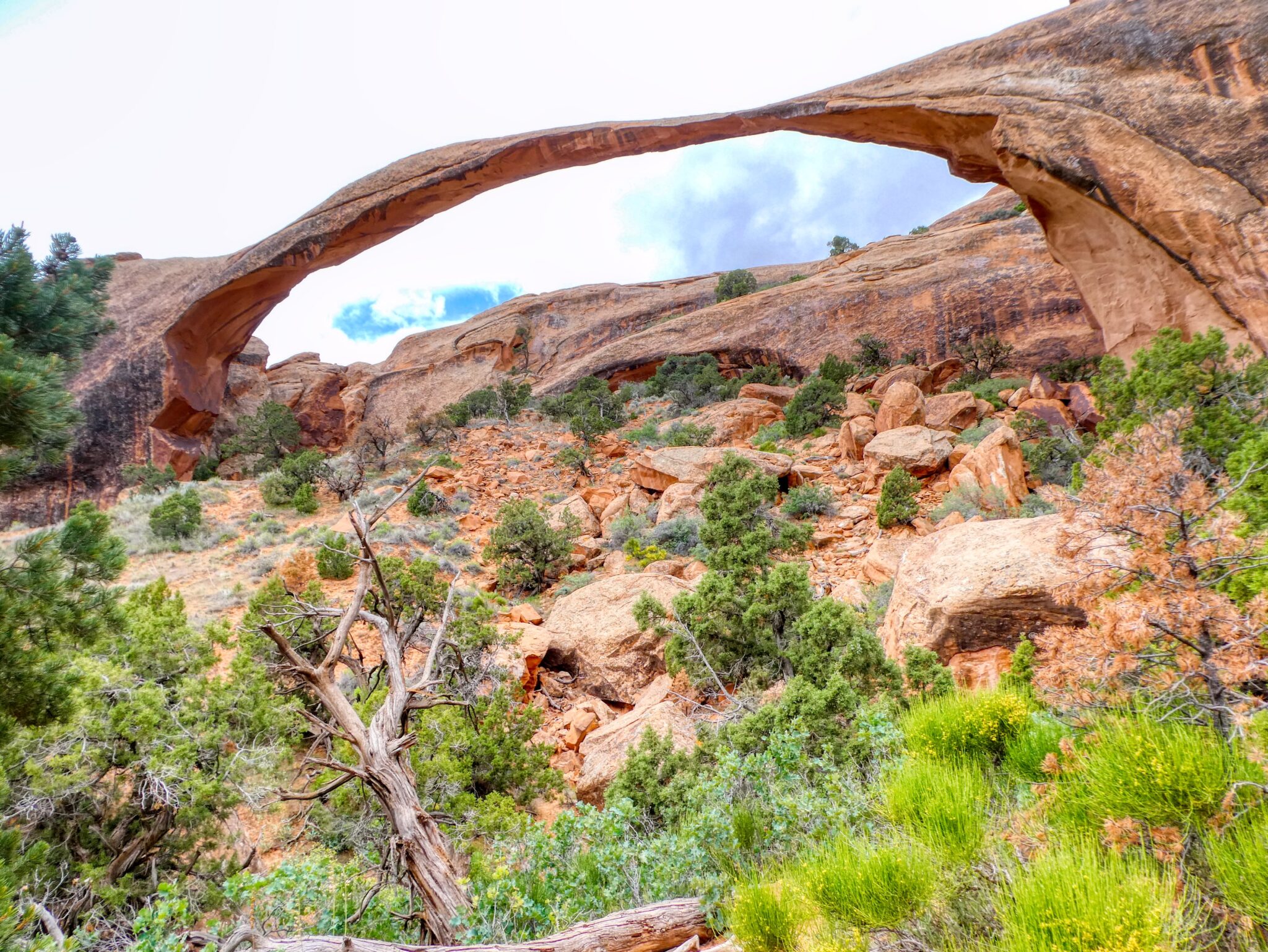
Pine Tree Arch (top of page), the other arch on this trail, is a massive rock structure and serves as a frame for some lovely scenery and the mountains beyond. Surprisingly, few people gathered around this arch and picture taking was somewhat easier. We waited for one couple to walk along and asked them to take a picture for us.

Picture time

Fortunately, our visit to Arches coincided with the blooming of desert wildflowers and cactus.  Helen took quite a few pictures of the blooming plants and a few are shared here.  The purple grasses also added greatly to the incredible scenery we enjoyed.

Landscape Arch is the widest arch in the National Park at over three hundred feet wide. In 1991, a huge slab of the arch fell from the underside that measured 60 feet long, 11 feet wide, and four feet thick.  This incident adds to the history of these formations that began as sandstone deposited over three hundred million years ago and shaped by wind, water, ice and other forms of erosion over the millions of years since. All arches in the park will succumb to the forces of nature eventually and crumble to the ground while new ones begin to form. Landscape Arch is a genuine natural wonder.

Landscape Arch – Arches National Park

Our hike continued beyond Landscape Arch to several viewing points within the park.  The signature formation in Arches is Delicate Arch, a trip that required 2 to 3 hours of hiking along a difficult trial and includes a climb up a steep rock slope. Although tempted, common sense prevailed and we decided to pass on this hike and walk to another viewpoint instead and use a telephoto lens to capture Delicate Arch. A picture below shows the rock climb at the beginning of the trail.

Delicate Arch trail
Spires – “The Three Gossips”
Buttes

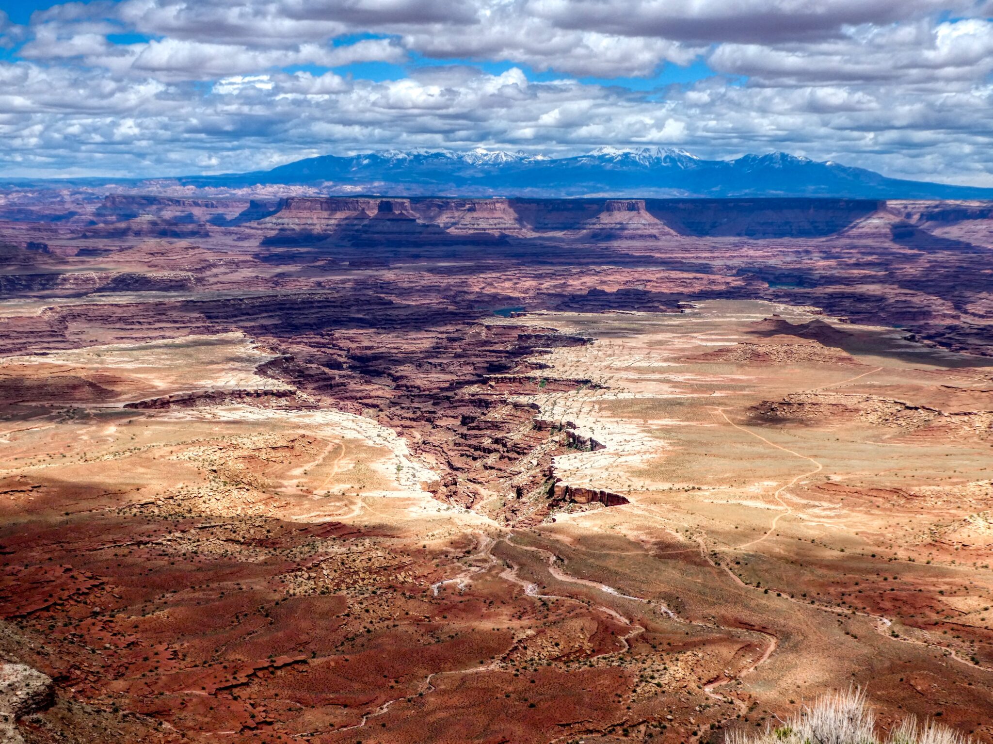
The hike to the Delicate Arch viewpoint allowed us to focus on the valleys and the unique terrain that makes this park so special.  The mesas, buttes, spires and balanced rocks within our view are very dramatic and seemingly endless in number. The colors found in the valley floors give details about the history and geology of each one. Iron (or a lack of it) is usually the element that determines the colors found here. Iron and iron oxide brings out the deep reds and a lack of oxygen is responsible for the greens and indicate an oxygen-poor environment such as an ancient sea bed.

The Delicate Arch viewpoint, located near the parking lot, had filled with visitors by the time we made it there, but there were plenty of vantage points available for picture-taking. Looking through the camera lens, I could see many hikers that had reached the arch and strolled through the opening in its base. I’m certain they all agreed that the reward at the end of the journey was more than worth the effort.

Delicate Arch – Arches National Park

Both Arches and Canyonlands National Parks are exceptional and serve to reinforce my belief that our National Parks are the greatest gifts Americans ever gave to ourselves. We love every visit we’ve made to one and, when we leave here, we’re Easing Along to another one of those gifts…Mesa Verde National Park.  We hope you’ll join us there.

Purple grass – Arches National Park


Posted in Fun

Moab Part One – Canyonlands National Park

Grand View Overlook, Canyonlands National Park

We had heard much about Moab, UT, but nothing prepared us for the real thing. The views are stunning, the town has a Wild West charm to it, and, with two of the country’s most scenic National Parks minutes away, there is plenty to do. We checked into Archview RV Resort, just a short distance from the entrance to Arches National Park, ready to take it all in. We pulled Lucy into our campsite, complete with a great view, and surrounded by off-roaders, hikers, and outdoor enthusiasts from all over the country.

Archview RV Resort, Moab, Utah

After unhitching and getting Lucy settled, we drove into Moab to explore the town. We arrived in the late afternoon. Temperatures were comfortable, so we decided to stroll the sidewalks, then stop for dinner. The streets were busy, but not overly crowded…until we reached the Moab Brewery and it was if everyone had vacated the sidewalks and piled inside this place.

Moab, Utah

Knowing that crowds like this are a good sign, we decided to stay and sample the offerings. We thought we would have to eat standing up until Helen coaxed a young waitress into giving us the high sign as soon as a customer was ready to leave. She worked with us and, in less than five minutes we had great seats close to the bar. The food was good and the beer was cold—a great start to our four-night stay.

Moab Brewery

With so much to do, we asked folks in the restaurant for suggestions. As expected, both National Parks came highly recommended but, if we chose to do Arches, we should plan on starting early to avoid the long line of cars that usually formed at the entrance. Not ready for an early start just yet, we decided to visit Canyonlands first.

Hiking along White Rim

Helen did some map work and determined that we should take Highway 313 out of Moab and drive about 20 miles to the Island In the Sky Visitor Center.  From there, we would hike along a broad canyon rim to the Grand View Overlook with stops at several overlooks and landmarks along the way. From the moment we stepped on the trail, the views of the canyon floor, some one thousand feet below us, were breathtaking.

Canyon Floor
Mesa Arch, Canyonlands National Park

Mesa Arch, our first stop, is a fifty-foot span that sits about 1,200 feet above Buck Canyon. Looking through the Arch, we could get a look at the snow-capped LaSal Mountains in the distance.  The arch also provided an eye-opening view of White Rim country as shown in this picture. A second picture gives a better view of the scale, as well as evidence of the popularity of this landmark.

Mesa Arch

The trail continues along the rim and Helen and I stood spellbound by the incredible formations below us.  We passed arches, mesas, buttes, spires, and canyons. Each formation defied description so I’ll post a few pictures and hopefully readers get an idea of the amazing display.

Mesa near Canyonlands NP
Rock pedestal


In addition to the rock formations, we had wildflowers to admire also. Although Canyonlands usually receives only 10 inches of rain per year, there was enough this year to bring out a nice display of desert primrose to enhance the beauty of our canyon hike.  The pinion-juniper also added some color beneath several interesting formations.


Desert Primrose

Additional stops at Buck Canyon Overlook and Grand View Overlook were just as amazing. The pictures show remnants of old roads and trails carved into the canyon floor during the days when Native Americans, cowboys, and uranium prospectors passed through before Canyonlands became a National Park in 1964. A close look at one picture from Buck Canyon, the Colorado River is visible in the far-off distance.

View from Buck Canyon Overlook

Grand View Overlook, the farthest point of our hike and pictured at the top of the paged, proved to be the most spectacular. A vast canyon stretched for miles and miles into the distance and the rock formations rose from the desert looking much like red totem poles.

This over-the-top experience was incredibly fascinating and truly unforgettable. I hope you enjoy the pictures because I can’t add much more in words…Goodbye for now—we’ll be Easin’ Along.

Posted in Fun

Blanding, Utah – Prettiest Place I Never Heard Of

Mountains just north of Blanding, Utah

I love travel surprises.

Originally, our plan after leaving Lake Powell was to drive to Moab, Utah but there was not a campsite available there on the dates we wanted. We reverted to Plan B and searched for a campsite halfway between Page, AZ and Moab. RV Trip Wizard, the app we use for route planning, led us to Blanding, Utah, a place unfamiliar to me. After reading some favorable reviews, I took a chance and booked Blue Mountain RV Park for two nights, not expecting much more than a place to park Lucy for two nights until we could leave for Moab. Fortunately, my expectations were way off the mark.

View from Blue Mountain RV Park

Blanding, Utah is a small town (pop. 3,300), about 35 miles west of the border with Colorado as the crow flies.  As depicted in the image below, there is not much there which only adds to the charm. We checked into the RV Park, a very clean and perfectly landscaped campground with a stunning view of the mountains to the north. Our new home was turning out to be a very pleasant surprise.  I love it when that happens. The weather was cold with snow in the area (elevation 6,100 ft), so we made a quick trip to a nearby supermarket for a few dinner items and settled in for the night.

Blanding, Utah

The next day we made use of the laundry facility at the campground where Helen met a nice couple that gave her some great information about what to do in the area.  This couple, residents of Missouri, told her that they had been hiking in the area for many years, but that things had changed a lot since Blanding had been “discovered”. At one time, she said, they could hike for days and never see a soul, but that things were different now.  Things still looked pretty sparse to me, but I had only been here for about 10 hours.

Natural Bridges National Monument

Acting on information from our new friends, Helen did some research and learned that Natural Bridges National Monument, another place I had never heard of, was a short distance to the west.  We finished our laundry and moved out.

Highway through the canyon

The forty-five-minute drive to the National Monument was delightful. Rock formations lined both sides of the highway and the wildflowers were out in abundance. About 10 miles into the drive, a wide curve in the road took us through a long, sweeping canyon bordered by high rock walls.  Before we crossed a ridge, I stopped to take a picture of the canyon.  The road we were on appears as a strip across the middle of the rock wall.

We made it to the Visitor Center of the National Monument and presented our National Park Senior Pass to the two Park Rangers behind the desk.  There were only two other visitors in the Center so one of the Rangers had plenty of time to give us information on the Park and the three Natural Bridges that are the main attraction. Loaded with an abundance of information, we began our self-guided driving tour of the Park.

Canyon wildflowers

A natural bridge is a rock formation that takes the shape of a bridge when water erodes the center portions of the rock over millions of years.  Ultimately, the entire rock formation will collapse because the erosion continues, but, for now, the Natural Bridges are awesome and fascinating structures. The three structures in the National Monument are named Sipapu, Kachina, and Owachomo.

Below, I have posted a picture and a few words about each bridge in the Monument. We could have hiked to each one, but we only had one afternoon to visit so, I took the pictures from overlooks along the road. The distance to the bridges may make them a bit hard to see.  I tried to place the bridge in the center of each photo and you can click on each picture to enlarge them.  

Sipapu

Sipapu Bridge (center above foliage)

The first of the natural bridges on the driving tour is the largest in the Monument and the second largest in the United States.  This natural bridge spans 268 feet and is believed to be the second oldest of the three.  The name Sipapu means “Place of Emergence” as members of the Hopi Tribe believed that this bridge was an entryway for their ancestors to come into the world.

Kachina

Kachina Bridge

This bridge spans 204 feet. The name comes from the rock art on the bridge that resembles Kachina dolls, wooden dolls carved by the Hopi that represent ancient spirits.

Owachomo

Owachomo Bridge

The last bridge on tour takes its name from the rock mound on the east end of the abutment. It is the oldest, smallest, and thinnest of the three bridges.  Owachomo spans 106 feet and is only nine feet thick.  This bridge is also the most photographed bridge in the Park.

Owachomo Bridge (NP photo)

Although we only had one day in Blanding, we felt we made the most of it.  A casual conversation in the laundry room turned into one more great day on our Lucy Does the Desert road trip.  We were lucky, but sometimes, it’s better to be lucky than good. It’s time to be Easin’ Along. We say goodbye Blanding. Thanks for all the surprises.